


MyRadar
News
—
Northeast Smoke-pocalypse: The Science Behind History
by Will Cano | News Contributor
6/7/2023
Wednesday, June 7, 2023 will forever be remembered as one of the worst air quality days in the Northeast's history due to wildfire smoke. Two Major League Baseball games were postponed. New York City is currently listed as the world's most air-polluted city. In Upstate New York, the smell of a late-night campfire remained consistent throughout the day without a flame in sight.
This is all due to wildfires that aren't even burning in the United States.
Canada has faced a harsher-than-average beginning to their annual fire season due to hot, dry, and windy conditions. However, the culprit of this specific spell of smoke can be attributed to a series of wildfires in southern Quebec. The fires began in early June, and 136,684+ acres have been burned so far, putting the region on track for it's worst wildfire season ever.
Wildfires happen in Canada every year, so why is 2023 the first time this is becoming a historic issue? This year's fires, wind conditions, and weather patterns have come together to bring the Armageddon-like smoke to our front doorstep.
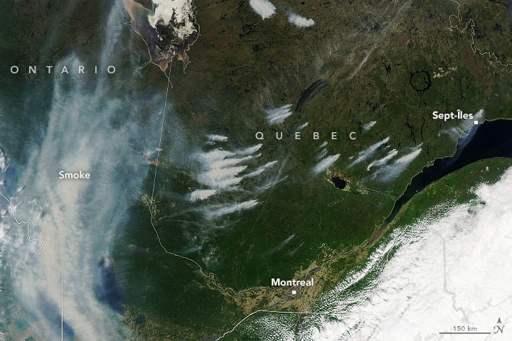
Satellite imagery showing the active wildfires and resultant smoke in southern Quebec on June 3rd, 2023. The smoke cloud to the West of the fires shows a wave that negatively affected air quality in Ontario and the Great Lakes. NASA Earth Observatory
The Cause
Contrary to the popular belief, the smoke from Quebec's fires has not just 'drifted' to the Northeast. Rather, it has been steered in this direction by the current wind patterns of our atmosphere.
Perhaps the most influential factor in this steering has been an ocean storm system located off of the east coast of Maine.
Storms are created by a center of low pressure. This low pressure causes the storm to circulate in a counter clockwise motion, and lift the air it is pulling towards it's center up higher into the atmosphere.
Presently, our storm helps being us smoke in two ways. First, the wind fans the flames, making them grow rapidly and thus produce more smoke. Secondly, the storm's circulation cause wind going north to south on its western side - right over Quebec. This brings the smoke straight from the active fires to the central Northeast.
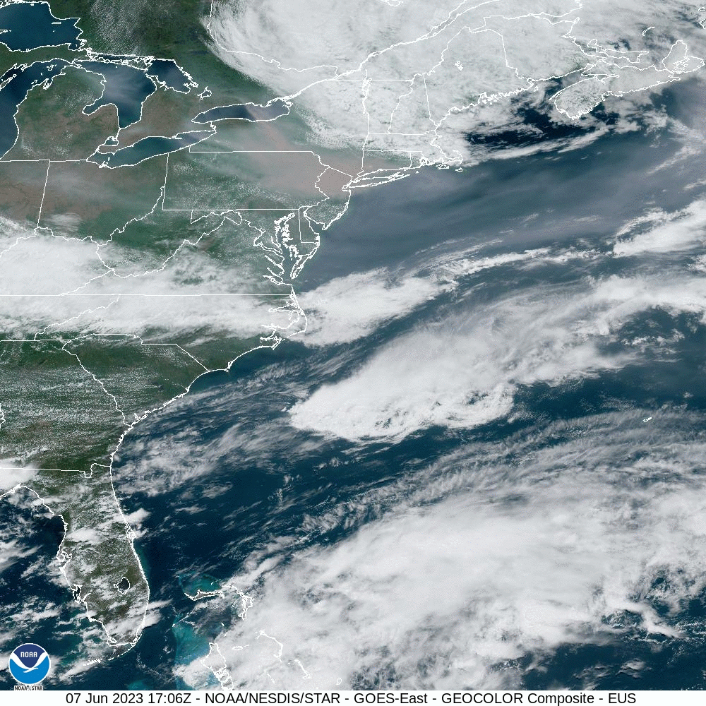
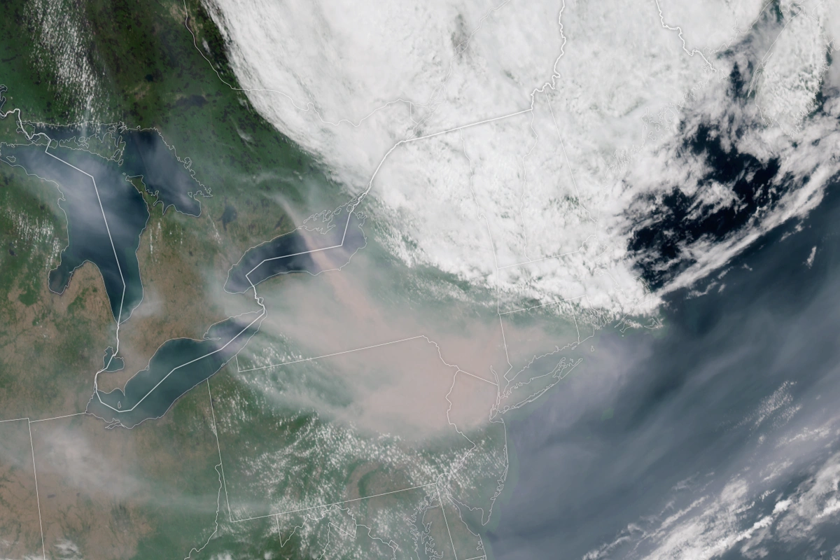
Satellite animation showing the low pressure system causing the smoke to be funneled from Canada to the Northeast on June 7th, 2023. The smoke plume can be seen swathing over the mid-Atlantic. NOAA GOES
To enhance this effect, a high pressure system known as an "Omega Block" is present over the northern Great Plains of the United States. As a result, a ridge is created, and the downslope of that ridge over the Great Lakes traps the air from escaping too far to the west.
To add on to all these factors, the weather over the last few weeks have led to these conditions. Dry and hot conditions have made wildfires possible anywhere across the northeast and southeast Canada. Just a week ago, we were experiencing a (more minor) smoke outbreak from wildfires in Nova Scotia. Recent wildfires in New Jersey and central Pennsylvania have sparked, also causing poor air quality locally.
🚨#WATCH: Apocalyptic before and after scenes from the wildfire smoke consuming the New York City skylines ⁰⁰📌#Manhattan | #NewYork
— R A W S A L E R T S (@rawsalerts) June 8, 2023
Watch breathtaking yet unsettling sight of apocalyptic scenes as the smoke from the Canadian wildfires engulfs the magnificent New York City… pic.twitter.com/e9ppS7ga44
The Numbers
Although this event is quite the opposite of a snowstorm or hurricane, meteorologists and health agencies have still developed a scale to measure the strength of this smoke invasion. One of these is the Air Quality Index, or AQI, which measures different types of pollutants in the atmosphere and how harmful they may be. The scale ranges from 0-500, and reflect how different groups may be affected by the air quality with different pollution concentrations.
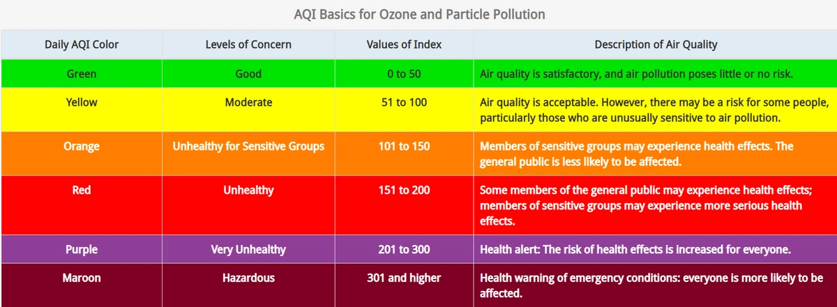
The AQI Scale and what different ranges mean for certain individuals. AirNow.gov
The problems start to begin at an AQI of 100, and the problems get serious over 300. At the time of writing this article, my current location in southeast Pennsylvania is registering an AQI of 431. In the New York City and Philadelphia regions, values even higher were recognized. Hazardous and Very Unhealthy conditions have been observed across the entire northeast. This makes the air quality extremely hazardous for all groups, especially those with asthma or other chronic lung complications.
One clever mathematician has compared this smoke inhalation to cigarette usage. The calculator to find this risk can be found here: https://jasminedevv.github.io/AQI2cigarettes/
The History
Wildfire smoke has always been a problem in areas close to a wildfire, yet this one is still worthy of the record books. Part of the reason is because it is so rare in the Northeast.
A temperate climate in the Northeast summer generally fosters rich green colors and not much room for wildfires to grow. If they grow nearby, winds rarely carry them in our direction as perfectly as they have with the current situation.
The story is different on the West Coast. Apocalyptic scenes of orange haze and smoke-filled skies are, in some places, an annual occurrence. This is because wildfire season stretches from June to October, with the weather conditions being perfect for wildfires throughout that time. The winds allow the smoke to be blown towards populated areas much more frequently than seen in the Northeast.
However, this particular anomaly is different. The density of smoke seen in the Northeast will rival record books in the West Coast as one of the worst air quality days in US History.
Is this just us East Coasters making a big deal of typical wildfire smoke? Nope. Yesterday was the 3rd worst smoke day in the Lower 48 & today is worse. After midnight, AQI averages will be totaled. Today has a good shot at the worst air quality day in U.S. smoke history! pic.twitter.com/Mzzmgxittw
— Bill Karins 💧 (@BillKarins) June 7, 2023
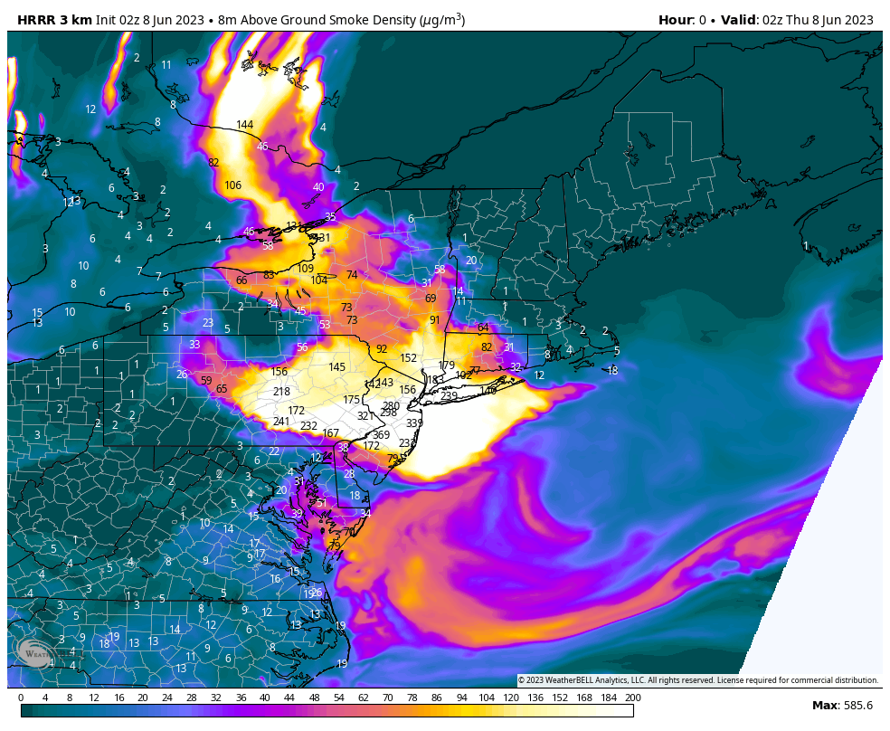
The Forecast
As the factors that have brought the smoke to the region change, so will the smoke that we see. Improvement will be gradual and will likely take through the weekend to disappear from the region. However, June 7 is still expected to be the worst day for most regions.
As the low-pressure system and Omega block change, the smoke will be directed to other directions. On June 8, more smoke will be expected over the Great Lakes and Ohio Valley than the Northeast.
Although hundreds of fires are still out of control in Quebec, reinforcements have been set to help fight the blazes, which also aims to improve the smoke spread in the long run.
Be sure to check the air quality by using the AQI feature on the MyRadar App before going outdoors.