


MyRadar
News
—
Scud Clouds: Meteorology's Misdiagnosed Phenomena
by Will Cano | News Contributor
7/12/2022
A tsunami in the sky? Wisps of fog racing towards you? A funnel cloud moments away from becoming a tornado?
Nope, it's none of the above. In all likelihood, you are witnessing a Scud Cloud: a mass of condensation that often intrigues, confuses, or even terrifies onlookers. Many people jump to conclusions on what these clouds may be, or what dangers they may bring with them. More often than not, however, they are not what meets the eye.
To truly understand what Scud Clouds are, one must uncover the science behind them.
It is important to note that the word "Scud" really isn't a word at all. It is an acronym, standing for "Stratocumulus Under Deck". This acronym explains that the clouds form at low heights, produce little rain, and are fluffy in nature. They match the description of the common Stratocumulus cloud, the most commonly seen cloud in the world.
A view of standard Stratocumulus clouds on a mostly cloudy day in St. Thomas (U.S. Virgin Islands). These clouds, the parent group of Scud Clouds, are noticeably fluffy and low. Image Credit: NASA S'COOL, Doug Stoddard
However, Scud clouds are unique because of their wispy, finger-like shapes which form at heights so low that they nearly scrape the ground. They form below the lowest layer of clouds in the atmosphere, or "under the deck" as the acronym describes. When many of these clouds form in unison, they can create stunning sights.
A recent and viral example of this phenomena was captured in Cincinnati, Ohio on June 13th, 2022.
This video caught the eyes of many in the vicinity, as the clouds appeared to roll between the ground and the sky like a towering tsunami.
So, what causes these mesmerizing monsters to form?
It's all about humidity. When rain is in the vicinity, warm and moist air is lifted vertically into the atmosphere. This is a rainstorm's updraft, or fuel. As the air rises, it must cool to match the cold temperatures of the upper atmosphere. While the temperature drops, the moisture remains, and a cloud is formed through condensation.
However, Scud Clouds form when the air is so humid that it cannot wait until higher levels of the atmosphere to condensate. Instead, the air becomes saturated just above the surface, and the condensation process begins below the height of the rest of the clouds. This process continues as the air rises higher, creating the vertically-oriented Scud Clouds seen in the video.
Scud Clouds can be formed in a few different types of environments. In Cincinnati, the Scud Cloud preceded a Derecho, or a large line of severe thunderstorms. The area was hit with heavy downpours and damaging winds just minutes after the video was taken.
It is for this reason that the clouds were so pronounced. A strong updraft was needed to fuel the intense storm, and with plenty of available moisture, Scud Clouds were created stretching high and wide.
Marion County, SC! #scwx pic.twitter.com/GkFjvuNQZZ
— Zach (@zachary_lane3) July 9, 2020
Thunderstorms often produce the best images of Scud Clouds because they naturally provide all of the ingredients necessary for their formation. This is another example from Marion County, South Carolina in 2020.
Scud Clouds may also form as a result of cold fronts. As cooler air is quickly ushered into a region, small pockets of warm, moist air may remain near the surface. This temperature difference forces the warm air to condensate low to the ground.
An example of this occurred in New Orleans, Louisiana last year due to warm, moist air rising off Lake Pontchartrain after a cold front swept through.
@ZackFradellaWx @DavidBernardTV @deauxb here’s another view pic.twitter.com/Dx3GzZcYri
— Raye Latham (@RayeLatham) March 1, 2021
Every Scud cloud has a unique shape based on the environment that it was formed in. This becomes problematic when Scud Clouds resemble much greater foes than they really are, like a tornado.
A Funnel cloud is the birth stage of a tornado — a column of swirling air that reaches down from the clouds towards the ground. Scud Clouds can closely resemble a Funnel if they have a stinger-like shape and they reach downward from a storm cloud. In reality, there are some noticeable differences between the two.
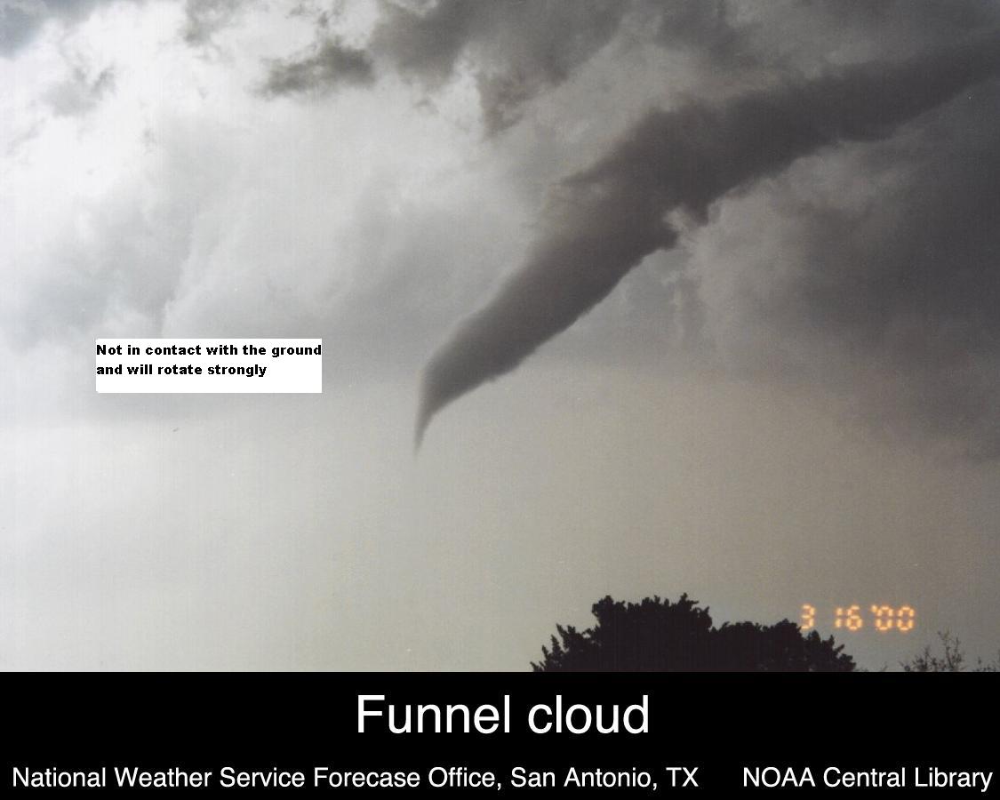
The image on the left shows a Scud Cloud (not compact, no rotation) versus an image on the right showing a funnel cloud (very compact, tight rotation). A Scud Cloud will never become a tornado. Image Credit: NWS Wilmington Ohio (left), NOAA Central Library (right)
A Funnel cloud has tight, rapid rotation along its vertical axis. In addition, it must be connected to the clouds above it, as that is a tornado's source of energy. Scud Clouds never have any rotational motion, and are able to detach from the clouds above them.
This is also the case for Wall Clouds — a disk-like cloud that descends from a thunderstorm before a tornado forms. These clouds also rotate, while Scud Clouds do not.
Finally, Scud Clouds are misdiagnosed to be tornadoes themselves. This is especially true in the cases where they seemingly stretch all the way to the ground. However, a tornado's rapid rotation will cause strong winds and debris to wrap around the point where the tornado touches the Earth. Furthermore, tornadoes usually have a crisp, full pipe of condensation all the way from the ground up.
Scud Clouds are often ragged and wispy, and produce no winds aside from the ones produced by the thunderstorms near them.
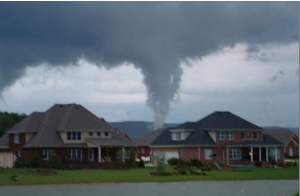
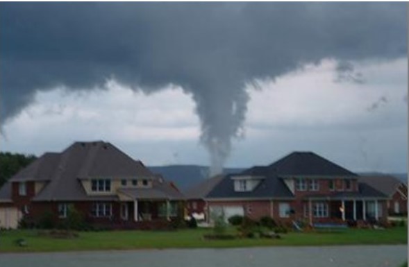
A Scud Cloud that very closely resembles a tornado, as the base of the cloud is hidden by houses in the foreground. Notice the ragged, loose structure of the cloud, and no debris in the air nearby. Image Credit: NWS Nashville
The unique formation, movement, and appearance of Scud Clouds lead them to become one of the most commonly misdiagnosed clouds in the sky. While they may disguise themselves as threatening adversaries, there might just be some reassuring science hiding behind them.
Next time you see a Scud Cloud moving in the distant sky, look out for these notable differences, and you'll know what you're really looking at.